Demystified
The Official INSPIRE Good Practice for Coverages.
Powered by rasdaman.
Validated by OGC and INSPIRE.
INSPIRE Coverages: From Mystery to Mastery
EU member states shall implement the INSPIRE directive by 2020, says the INSPIRE roadmap. Still, there is a significant amount of uncertainty especially on coverages, that is: raster data and services:- What do INSPIRE coverage metadata look like?
- What is the correct INSPIRE coverage representation?
- How to build an INSPIRE-conformant WCS?
Here is the good news: it's not that difficult actually, know-how and technology is available! This site educates on and demonstrates INSPIRE coverage services, established by a team of key OGC and INSPIRE experts and powered by OGC-certified and INSPIRE Good Practice platform rasdaman.
For an overview and introduction to WCS use in INSPIRE, here is a INSPIRE Web Coverage Services webinar by Kathi Schleidt, DataCove. For more details, see this WCS and WCPS tutorial by Peter Baumann, rasdaman.
(Datasets provided by ICGC, Barcelona, Spain
and SYKE, Helsinki, Finland
and Landesamt für Vermessung und Geoinformation Schleswig-Holstein, Kiel, Germany)
By INSPIRE Theme:


By Client:


Coverages and WCS: Basics
So what is a coverage? Coverages are the worldwide accepted concept for representing raster data, used by OGC, ISO, and INSPIRE (they can also represent point clouds and general meshes, but typically focus is on raster). OGC maintains a large collection of tutorials, webinars, and working examples in the coverage data and service model.
The coverage data model: A coverage consists of a domain set ("where are the data located?"), a range set (the pixel payload), a range type ("what is the semantics of these data?)", and some arbitrary metadata ("what else should I know about these data?"). While OGC and ISO agree on an interoperable coverage definition with broad format encoding support, INSPIRE has established its own, non-interoperable definition which is causing significant confusion in the INSPIRE community; moreover, this coverage model contains several technical flaws, and some experts also consider it unnecessarily complicated. We have made a proposal to realign with OGC and simplify INSPIRE coverages, with corresponding schemas amending the OGC Coverage Implementation Schema (CIS) 1.0 with INSPIRE metadata for orthoimagery, elevation, and land cover.
The coverage service model: The INSPIRE WCS Technical Guidance mandates OGC WCS Core and optionally adds OGC WCPS. As OGC WC(P)S operates on the OGC coverage model, INSPIRE WCS consequently operates on the OGC coverage model, Coverage Implementation Schema (CIS), and bypasses the INSPIRE coverage definition. However, such coverages must duly contain INSPIRE metadata in the coverage's metadata compartment, in coherence with the OGC CIS and WCS provided extension mechanisms. The open-source rasdaman engine used by this portal is OGC WCS certified and, at the same time, provides proper INSPIRE metadata.
OGC OAPI-Coverage: Currently an effort is underway to unify OGC feature, coverage, map, and processing services based on the OpenAPI concepts. From a WCS perspective, this is an evolution, not a disruptive replacement: first, the new OAPI-Coverage specification is based on the OGC Coverage Implementation Schema (CIS) 1.1. Second, effort is devoted to maintain coherence - OAPI-Coverage from a WCS perspective should resemble just another "protocol binding" which can be used interchangeably with GET/KVP, POST, and SOAP.
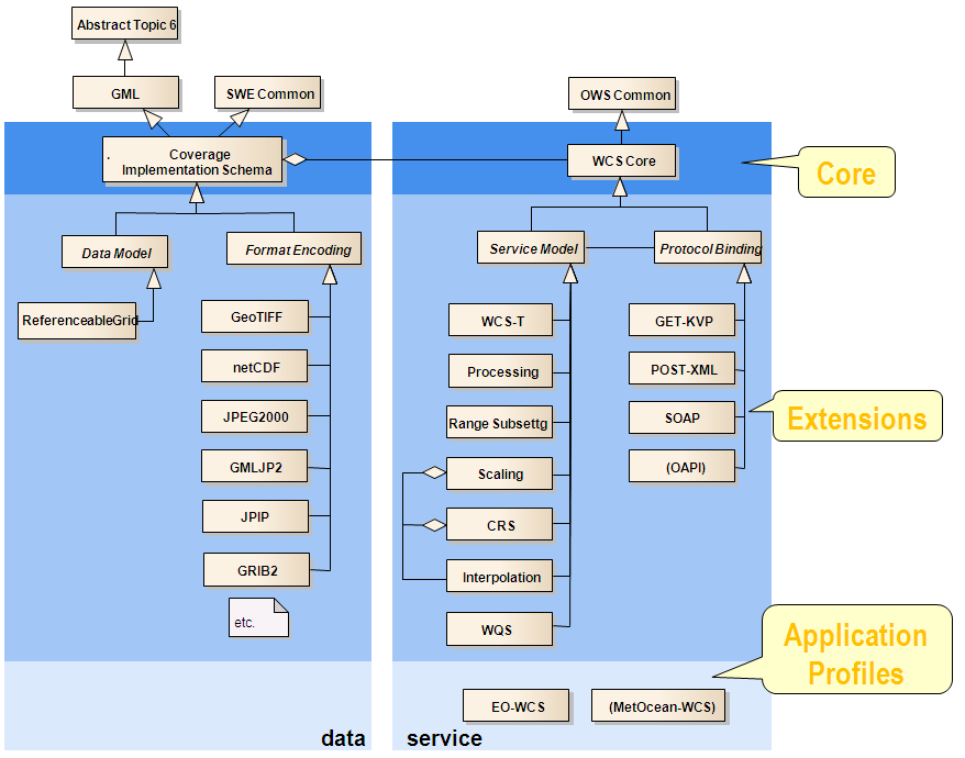
The OGC/ISO Coverage ecosystem: The coverage data and service model, including OAPI-Coverage, form a powerful, versatile ecosystem of coverage functionality. The following diagram shows the complete WCS suite with its components and their relationships:
Conformance testing: OGC provides a rigorous conformance test suite validating implementations down to pixel level. The INSPIRE conformance test inspects validity of INSPIRE metadata; all other properties are addressed by the OGC conformane tests. Hence, an INSPIRE conformant WCS implementation must pass both tests.
Coverage standards: The authoritative source for coverage data is the OGC Coverage Implementation Schema, which is also ISO standard (ISO 19123-2:2018) and (via WCS) also authoritative for INSPIRE. Further definitions, such as by W3C or definitions solely relying on the abstract model of ISO 19123, are not authoritative, not interoperability-proven, not as rigorously implementation-tested as OGC CIS is, and not with the multitude of implementations supporting it. OGC/ISO coverages can be served via OGC WCS/WCPS (which has the most dedicated coverage functionality), but also OGC WMS, WPS, and SOS.
More on INSPIRE Coverages
- INSPIRE Coverages Candidate Good Practice webinar 2021
- Practicing Coverages Workshop 2021
- INTERGEO INSPIRE Coverages 2020
- INSPIRE 2020 workshop: Coverages Demystified
- INSPIRE Helsinki WCS/WCPS workshop
- OGC Spatio-Temporal Coverage / Datacube Standards Wiki, with ample educational material, examples, etc.
- P. Baumann, J. Escriu: INSPIRE Coverages: An Analysis and Some Suggestions. Open Geospatial Data, Software and Standards, 4(1)2019
- K. Schleidt, P. Baumann: Interconnecting Sensor Data and Datacubes. Proc. IEEE Geoscience and Remote Sensing Society (IGARSS), July 28 - August 2, 2019, Yokohama, Japan
- D. Misev, P. Baumann: Despite Open Data: How to Secure Pixels Appropriately? Proc. IEEE Geoscience and Remote Sensing Society (IGARSS), July 28 - August 2, 2019, Yokohama, Japan
- P. Baumann, D. Misev, V. Merticariu, B. Pham Huu: Datacubes: Towards Space/Time Analysis-Ready Data. In: J. Doellner, M. Jobst, P. Schmitz (eds.): Service Oriented Mapping - Changing Paradigm in Map Production and Geoinformation Management, Springer Lecture Notes in Geoinformation and Cartography, 2018
- OGC/INSPIRE WCS and WCPS in Action
Questions? Need Help?
Contact us - we gladly share our experience and insight from many years of writing and implementing OGC, ISO, and INSPIRE standards.
This service demonstrates use of coverages and WCS/WCPS for several INSPIRE themes, powered by the rasdaman WCS reference implementation and offering data provided by Institut Cartogràfic i Geològic de Catalunya (ICGC). Bringing INSPIRE coverages to life is a passion of the "gang of three" (in inverse alphabetical order), supported by the rasdaman team:
- Kathi Schleidt, Data Cove E.U.
- Jordi Escriu, Institut Cartogràfic i Geològic de Catalunya (ICGC)
- Peter Baumann, Professor of Computer Science and CEO of rasdaman GmbH; he is the main shaper of the OGC Coverage Implementation Schema (CIS) and Web Coverage Service (WCS), and also driving datacube standardization in ISO.
This service is for demonstration purpose only. It does not offer authoritative data nor services, and it may not be used for any kind of geospatial decision making.
Responsible Maintainer
Constructor University Bremen gGmbH
Campus Ring 1
28759 Bremen
External Links
All external links implemented on this site have been checked for conformance with the spirit and intent of this site, and have found conformant at this time. However, the maintainer of this site has no control over the (change of) contents of the referred websites and, therefore, does not assume any responsibility for the contents of referred websites.
German Data Protection Regulation (GDPR)
The controller responsible for the described data collection and processing is rasdaman GmbH. Our data protection officer, the rasdaman GmbH CEO Peter Baumann, (contact see About), will be happy to provide you with information or suggestions on the topic of data protection.
When you visit our website, the Web server temporarily stores usage information on our server machine (running in Germany) for statistical purposes in the form of a log in order to improve the quality of our website and to fulfill funding agency statistics reporting obligations.
We do not transfer your personal data to third parties without your express consent. We use revolvermaps for determining the city of visitors (nothing beyond this anonymized inf ormation is available); see their privacy statement which, at the time we evaluated it, obviously was in accordance with GDPR.
When it comes to processing your personal data, the GDPR grants you certain rights as a website user:
- Right of Access (Art. 15 of the GDPR): You have the right to request confirmation as to whether personal data concerning you is being processed; where this is the case, you have a right of access to this personal data and to the information specified in Article 15 of the GDPR.
- Right to Rectification and Right to Erasure (Art. 16 and 17 of the GDPR): You have the right to immediately request the rectification of incorrect personal data concerning you and, if necessary, the completion of incomplete personal data. You also have the right to request that personal data concerning you be erased immediately if one of the reas ons listed in Art. 17 of the GDPR applies in detail, e.g. if the data is no longer required for the purposes for which it was collected.
- Right to Restriction of Processing (Art. 18 of the GDPR): You have the right to request a restriction of processing for the duration of a review if any of the conditions s pecified in Art. 18 of the GDPR have been met, e.g. if you have lodged an objection to the processing.
- Right to Data Portability (Art. 20 of the GDPR): In certain cases (which are outlined in detail in Article 20 of the GDPR), you have the right to obtain from us your personal data in a structured, standard, machine-readable format or to request the transfer of such data to a third party.
- Right to Object (Art. 21 of the GDPR): If data is collected on the basis of Art. 6(1)(f) of the GDPR (data processing on the grounds of legitimate interests), you have the right to object to the processing at any time for reasons arising from your particular situation. If you make such an objection, we will no longer process your personal data un less we can demonstrate compelling legitimate grounds for the processing which override your interests, rights, and freedoms or for the establishment, exercise, or defense of le gal claims.
- Right to Lodge a Complaint with a Supervisory Authority In accordance with Art. 77 of the GDPR, you have the right to lodge a complaint with a supervisory authority if you believe that the processing of your personal data violates data protection regulations. This right to lodge a complaint may particularly be exercised before a supervisory autho rity in the EU member state where you reside, work, or where you suspect that your rights have been infringed.